


|
Stockton, Warwickshire - The village of Stockton lies in the local government district of Shakespeare’s town of Stratford- The Victoria County History of the County of Warwick states that Stockton is not named in the Domesday Book, the record of the "Great Survey" of much of England and parts of Wales completed in 1086 by order of King William the Conqueror. It is first known of in connection with Gualter (Walter) de Somerville, born in Normandy, who owned land in Stockton in the reign of King Henry II (1133- The origin of the name Stockton is not entirely clear. "Ton" is a typical Anglo- Walter de Somerville gave the church at Stockton (which would have had lands to support it) to the Priory of Hertford, so it does seem possible that in this case the place- Six hundred years later, Stockton was still just a small agricultural village, covering some 1,400 acres (500 hectares). It occupies a low hill in the gently sloping countryside of south-
Rev. Tuckwell was known as The Radical Parson. A Christian Socialist, he believed in the nationalisation of land and divided up some of the Glebe (church) land into allotments for the villagers. A second notable Stockton incumbent was the Edwardian “Archdeacon” Colley (apparently a self- In 1801 the population of Stockton was just 274, but by the end of the nineteenth century it numbered nearly a thousand. What sparked the greatest changes in the entire history of the village was the discovery in 1792 of "a rock of limestone". With increasing urban and industrial expansion, what proved to be stone of exceptional quality was in great demand and Stockton became an industrial village with quarries and cement works. The renowned Blue Lias waterproof cement was used in iconic projects from the Eddystone Light to the Houses of Parliament and the British Museum. The Blue Lias limestone, early Jurassic, was laid down 200 million years ago, and is famous for its marine fossils, especially ammonites. The National History Museum in London houses a fossilised ichthyosaurus, almost three metres long, found at Stockton in 1898. This strange fish- Today, quarrying is still carried on in the area around Stockton, while the visible local legacy is deep pools where once the quarrymen toiled, and rows of former cement workers’ cottages built of yellow brick made from clay taken from the pits and fired locally. This website focuses on the Griffin family who farmed at Stockton for 150 years, and in the nineteenth century also had a small lime and cement works, the history of which is described. The family therefore represented the two faces of this Warwickshire village.
|
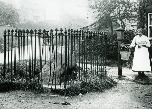 This photograph shows what became known as the Stockton Boulder. The lump of granite was found along the road to neighbouring Napton-

| 2 Sitemap |
| 3 Maps |
| Late Victorian map of Stockton |
| Pre 1844 O.S. map Stockton-Long Itchington |
| Stockton Fields - 2 |
| Stockton Fields - 3 |
| Stockton Fields - 4 |