Rambling routes in the Cotswolds and surrounding areas
Rollrights-Chipping Norton
Print route: |
 Leaving Great Rollright to join the D'Arcy Dolton Way 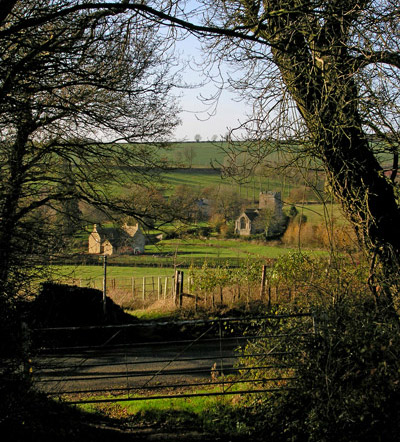 Nearing Little Rollright 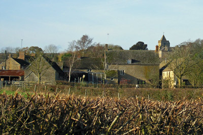 Village Farm & church, Salford More photos from the walk |
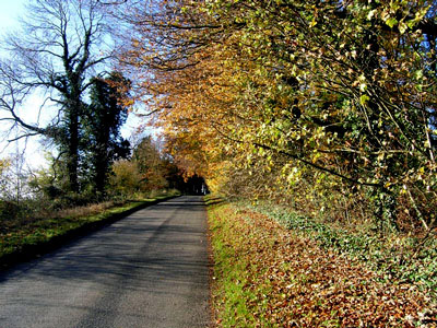
Great Rollright-Rollright Stones-Little Rollright-Salford-Chipping Norton, Oxfordshire. Explorer Map 191 Distance: about 5½ m./9 km. Ascents: 65 m. Descents: 100 m. Approx. time excluding stops: 2 hrs 15 mins. Allow 20-30 minutes to visit the Rollright Stones. Overall time around 3 hours. General Description: The walk crosses open countryside, with fine views despite there being very little climbing. It visits the prehistoric Rollright Stones with their legends of treachery and witchcraft, and the pretty Cotswold hamlet of Little Rollright. For about the first 4 miles, the walk follows the 66-mile long D’Arcy Dalton Way which links Wormleighton in Warwickshire with Compton Beauchamp, Oxfordshire. Our route is well waymarked throughout and much of the walk follows grassy bridleways or paths. In wet conditions there should be only the odd short muddy stretch, but beware of one or two very slippery stiles, out of eight or nine in all. Access: Great Rollright and Chipping Norton are on the Stagecoach 488 bus route (Banbury-Chipping Norton). If coming by car, it is possible to park in Great Rollright and after the walk return by bus from Chipping Norton, or drive to Chipping Norton and catch the 488 to the start of the walk. After a morning walk, either variant offers the option of ending with lunch in one of "Chippy's" many pubs and restaurants, or with fish and chips or another takeaway. In Chipping Norton, use the free car park off New Street; go up the hill to the top of New St. and turn right to find the bus stop a few yards along on the rt. Map (note: Doctors/First Aid are now up London Road). Start of walk: Bus stop at The Green in Great Rollright village, map. ref. SP322312. Route: Walk N. up the road (Hemplands) to the end of the village. After a furlong (220 yds/200m), at the crossroads, turn left (W) onto the road towards Long Compton and Little Rollright. Walking on the right, follow the road (top photo on this page) for about 500 yds: it descends into a dip and then climbs again. Half-way up, where visibility is good for walkers and drivers, cross over onto the left; if necessary use the grass verge for these final few yards. At the top, turn left (WSW) through trees onto a footpath signed “D’Arcy Dalton Way”. At the end of the woodland track continue straight ahead along the field margin; then continue ahead to the line of trees bordering the A3400 road (1¼ mls/2 km). On arrival, bear left and skirt the trees for a few yards to reach the steps in the corner of the field. Cross the road using the steps on both sides. After crossing the road, fork right into a field and continue ahead, crossing two fields to reach Brightwell Farm. Straight ahead over two stiles. Pass through a coppice and at the end, climb two more stiles. Immediately, to begin the short detour to the Rollright Stones, turn right (NW) off the D’Arcy Dalton Way and use the permissive path along the field margin to reach the first of the stones, “The Whispering Knights”. An information panel describes their history and associated legend. Continue ahead up to the road but do not leave the field. Turn left along a grassy track inside the road hedge to reach the King’s Men Stone Circle (photo on the home page). Just before reaching the circle, on the right is an exit onto the road, with another information panel. After visiting the King's Men, use this exit and cross the road into Warwickshire to visit the solitary King Stone. You need to retrace your steps along the track inside the road hedge and pass the Whispering Knights to regain the D’Arcy Dalton Way. Here, turn right (SW) and, crops permitting, go straight ahead across the field track. Do not follow the grassy field margin down the hill (SE), as this only takes you round an unnecessary detour. On the far side of the field continue ahead. As you descend, the church of Little Rollright comes into view. At the bottom of the hill, reach a metalled road in the hamlet of Little Rollright (2½ mls/4 km from the start). Cross the road and bear left to follow the narrow path between hedges, now in a southerly direction. There is no further real change in direction until arrival at Salford. Following the waymarks, leave the hamlet behind, a short ascent leading to two metal kissing gates on Manor Farm. Continue ahead across the slope, with Chipping Norton visible across the valley to the left (E.). Further on, discs on the right, on each post of a field gate, indicate we go through and turn left along the other side of the hedge. (If you miss the waymark discs, no matter, the track you are on will lead you to Salford). Follow the path through the wood ahead and emerge over a stile, crossing fields and more waymarked stiles: bear left across the last field in front of Rectory Farm house to reach the edge of the village of Salford. Descend Roses Lane; at the bottom of the hill, a footpath sign on a wall to the left reads “Chipping Norton, 1½ miles” (measured on the map, the distance is rather less). (4¼ mls/7 km. from start). Optionally, turn right and continue a few yards to the village pub, opposite the Village Hall. From the Chipping Norton footpath sign, leave the D’Arcy Dalton Way and Salford, heading E. and passing between the buildings of Village Farm. Follow a clearly defined track, then path (the Shakespeare Way) straight ahead, gaining height until the town of “Chippy” appears over the ridge. Crossing two access roads, continue down to the bottom of the hill. A slight deviation to the left passes the Communal Orchard; keep right to reach a thoughtfully placed seat adjacent to the cemetery. The two variants converge at a footbridge over a stream; cross this to reach the Recreation Ground. Exit onto New Street, climbing the hill past the Baptist Church. Cross the road back to the Chipping Norton New St. car park (5½ mls /9 km.). End of walk. |