Rambling routes in the Cotswolds and surrounding areas
Dassett Hills circular
Print route: |
The beacon tower, Burton Dassett Hills Country Park 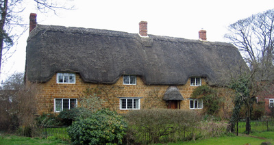 Cottages in Fenny Compton 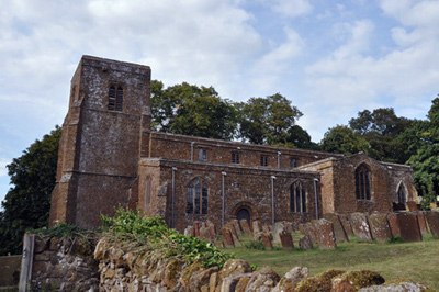 All Saints, Burton Dassett, from the Centenary Way |
Avon Dassett - Fenny Compton - Burton Dassett Park - Avon Dassett, Warwickshire. Explorer Map 206 Distance: about 5½ m./9 km. Ascents: 65 m. Descents: same. Approx. time excluding stops: 2 hrs 15 mins. General Description: An easy walk across fields to Fenny Compton and Northend is followed by a short climb of 200 ft (65m) to Windmill Hill in the Burton Dassett Country Park. There are fine views here in all directions, which compensate for the hiss of traffic down in the valley, on the nearby M40 motorway. On a clear day the Malvern Hills are visible, forty miles to the west. A gentle descent over pastureland along the Centenary Way leads back to the starting point. The walk is well waymarked along the whole route, although a little care is needed not to stray off the line of the footpath when approaching Northend. The round stone structure on top of the hills, known as “the beacon”, is a successor of an original reputed to date from the 15th century: it may also have been used as a windmill. A few yards away, on the adjacent hillock, there was indeed a windmill, which ceased working in 1912 and was destroyed in a storm in 1946. Facing the beacon, to the NE, is Pleasant Hill, where in 1908, 35 6th or 7th century skeletons were found, together with a Saxon sword. Damage to the bones suggests they died in battle. The population of Burton Dassett in Norman times has been estimated at an incredible 350; gradually, inhabitants of the rich estate originally owned, even after the Conquest, by Saxon barons de Sudeley, moved down into the valley. The earliest fabric of the outstanding church of All Saints dates from the 12th century, although a church is mentioned in the Domesday Book. Its walls are built of mud faced with stone and its nave climbs the slope of the hill from the tower to the chancel. There are early wall paintings and delightful stone carvings, such as a dog chasing a hare, a squirrel eating a nut, and that symbol of rebirth, the “green man”. Access and parking: Avon Dassett is close to the Banbury to Warwick road (B4100), or can be reached from the A423 (Banbury to Southam road) through the village of Farnborough. Buses are very infrequent. In centre of village on road to Fenny Compton, park on roadside, opposite the pub, or a little higher up the road. Burton Dassett Hills Country Park can also be reached by car, and is an alternative start-finish point: there is a pay and display parking charge (₤2 for the day in 2019). Toilets. Start of walk: Village pub, Main St, Avon Dassett. (map ref SP410500). Known as The Yew Tree in 2019: now owned by community shareholders so unlike many village pubs should avoid closure. Tel. 01295 690868. Website. Route: From pub, follow road up hill (NNE) to Parish Church (not to be confused with Catholic church near pub). Immediately past church leave road by footpath on right, at corner of churchyard. The path climbs to a drive: cross this, climb a stile and bear left down the side of the field. At the bottom, continue ahead, passing an old stonepit shortly before reaching the Farnborough road. Cross this, climb the waymarked stile, and continue ahead (N) down one field and up another, to a holly hedge near Hill Top Farm. With the hedge on the left, continue straight ahead, then cross more fields to reach another road. Turn left (NW) and follow it into nearby Fenny Compton (2 mi/3 km). Reaching the T-junction by Rectory Farm, turn right (N), and a short distance down the slope, take the footpath on the left by the junction with Grant’s Close. The path follows a westerly direction, crossing several flat fields with waymarks at the boundaries. Finally, the footpath reaches a large open pasture, with the slopes of Pleasant Hill away to the left (SW). Walk diagonally uphill across the field, aiming for the building visible on the far side. On arrival follow the track a few yards uphill to a waymarked stile on the right (W). Go over this and cross the ridge and furrow, climbing a little, to a metal kissing gate. Bear right (NW) and descend next field to another kissing gate by houses on edge of village of Northend, in the parish of Burton Dassett. A few yards ahead, reach a road at footpath sign reading “Fenny Compton 1½ mls”. Turn left (S) and follow road a short distance uphill to waymarked cul-de-sac on left (SE), at Stone Cottage. From the top of the cul-de-sac, there is a steady climb up the slopes of Bonfire Hill and Windmill Hill, (10 to 15 mins.), to get to the round beacon tower atop Burton Dassett Country Park (4 mi/6 km from start). Below, to the left (SE), a narrow road follows the ridge past the park-keeper’s hut and toilets. Ahead (S), Burton Dassett church is visible. Now on the Centenary Way, follow the road to the church, which is well worth a visit. Go through the churchyard and follow waymarks downhill (S, then SE) over stiles between pastures, until houses of Avon Dassett are close ahead. Here a waymark indicates a fork right (S) diagonally across two fields. The path emerges by the public house, (5½ mi./9 km): end of walk. |