Cornwell (Oxfordshire) - Adlestrop (Gloucestershire) - Chastleton (Oxfordshire) - Cornwell (circular).
Map: Explorer OL 45: "The Cotswolds". Distance: about 5½ m./9 km. Ascents: 525 ft.or 160 m. Descents: same. Approx. time excluding stops: 2 hrs 15 mins. For an extended walk via Daylesford village, click here.
Allow plenty of time for exploring, and consider a possible visit to Chastleton House (NT) during or after the walk.
General Description: A well waymarked walk over undulating countryside, mostly pasture land, and in places, touching woodland. Apart from lovely views, it offers considerable cultural and historical interest.
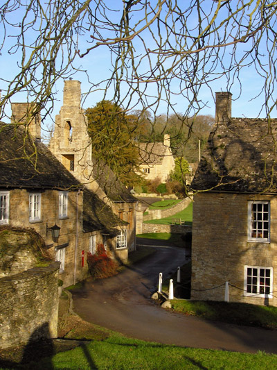
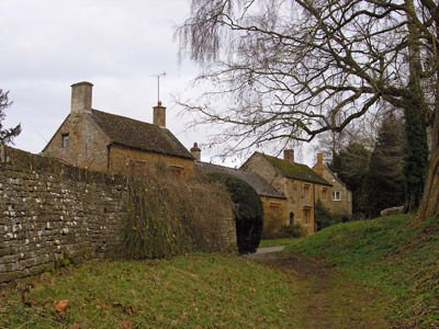
Cornwell is a tiny Cotswold estate village with a difference. It is full of houses with the typical limestone walls, mullioned windows and stone roof tiles, but, to quote architect Philip Wilkinson, also has more than its fair share of whimsical details, such as gate posts with big ball finials, fine cottage door canopies with curvy stone brackets and big chunky buttresses, and a village hall with a bell turret. Architect Sir Bertram Clough Williams-Ellis, best known for his Italianate village at Portmeirion in Wales, left his mark here in the 1930s.
From Cornwell, the walk crosses the immaculate Daylesford estate, formerly the property of Warren Hastings and today owned by the billionaire Bamford family (if the surname means nothing to you, look at the initials of the founder of the family firm, Joseph Cyril Bamford.)
Adlestrop is possibly best known for Edward Thomas’s lovely poem of the same name, published in 1917, the year in which he was killed in action in the Great War. It was born of the peace which does still exist in the hamlet, unlike the long-gone railway halt where, when the poet’s train stopped, the surrounding tranquillity so inspired him. A station sign and bench, with a metal plate engraved with the famous lines, have been installed in a bus shelter on our route. There is more to dream of here: Jane Austen made several visits to her mother's cousin Rev Edward Leigh of Adlestrop Park, said to be the inspiration for the location in her novel Mansfield Park. And you may encounter some of the magnificent horses from National Hunt trainer Richard Phillips’ Adlestrop Racing Stables.
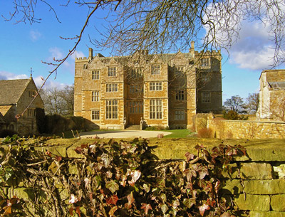
Chastleton House is one of England's finest and most complete Jacobean houses, today a National Trust property. On the croquet lawn here, rules were developed in the 1860s which became the definitive version followed since then throughout the sport. In the 1950s, the then owner of Chastleton would complain to visitors that the family never had much money, as they had lost it in the war - The English Civil War, that is.
Access and parking: Follow signs from the A44, near Salford, or A436, from Adlestrop crossroads. On arrival at Cornwell, park in the lay-by at the junction signposted <Chipping Norton - Adlestrop> and Moreton-in-Marsh or go a few yards down the Moreton road and park on the left down the slope.
Start of walk: Cornwell, layby, at junction signposted <Adlestrop-Chipping Norton> and Moreton-in Marsh. (map ref. SP270271). Walk E. along road, with village on left, passing an estate entrance. At footpath sign, climb steps on right up bank and turn right again (SW) once in field. Walk diagonally across field to Manor Farm, over stile and past farm buildings up slope. Alternatively, simply take the farm road ("Manor Farm") opposite the layby. Cross minor road into Kingham parish (Glos.) and continue ahead across Whitequarry Hill, along edge of wood, to estate road. Turn right (NW) and ascend to Daylesford Hill Farm (1 mi/1½ km).
At junction of paths by farm buildings, continue ahead across estate land, on path between fences. At end, with a sculpture (cornucopia?) in view ahead, turn right (NW) and then right again, following waymarks, and after some 30 or 40 yards, left through trees to adjacent A436 road to Stow-on-the-Wold. Here, turn left (SW) by West Lodge, opposite minor road to Adlestrop, and walk along wide verge by main road until footpath sign appears opposite. Cross road and take path, entering wood. Footpath continues parallel to Adlestrop road until finally it joins it. Soon after, take first turning left (S) into Adlestrop (2¼ mi/3½ km from start).
Walk down hill past Post Office. At bottom, pass railway sign in shelter and cross road onto path signed Macmillan Way (NNE). Cross fields and where path forks (three waymark discs) bear left across field, then follow hedge and ditch to stile in far corner. Follow well-defined track NNE over more fields and waymarked stiles, climbing to line of trees. Soon after, at top of ridge, Harcombe House, Chastleton, appears just ahead, to the left, and path reaches road near Chastleton House, next to church (3¾ mi/6km from start).
Path follows road E. past front of House then turns SE. Still on road, climb hill, and at top, on sharp bend to right, leave road on left, by cattle grid, and join adjacent bridle way on rt., crossing field (still SE). Ahead, path meets farm drive to Barrow House, visible to left (ENE). From here, there are three ways to complete the walk; two are given on page 2. Option (1) is to turn right (SW) on drive** then left (SSE) down a minor road 500 yds/0.5 km to crossroads with A436, at Cornwell Holt. Cross road; on far side, bridle way on left leads across three fields back to road below layby by junction to Moreton, in Cornwell (5½ mi /9 km.): end of walk.
**Optionally, continue ahead on path for some 200yds to visit Chastleton Barrow, an Iron Age hill fort marked by a circle of trees, then retrace your steps to this junction of paths near Barrow House.
Other route options from crossing of footpaths near Chastleton Barrow:
(2) Continue ahead across barrow down path to main A436 road and cross onto single track road which reaches Cornwell after 1 km/just over ½ mile. Good option if ground wet underfoot, as bridle way to village (see above) involves crossing a potentially very muddy field. Same walk length as main option above without detour to barrow. Arriving at Cornwell, via footpath on left (E) (“D’Arcy Dalton Way”), church may be visited.
(3) Cross barrow and at A436 turn right (SW) and follow road along wide verge for 5 mins to reach Cornwell Holt crossroads (see Option (1)) and join bridle way to Cornwell. Same distance as option (1) plus ** detour.
Extended walk (length 6½ mi/10.5 km, i.e. adding a mile to the total)
At junction of paths at Daylesford Hill Farm, turn left (SSW) and descend to Kingham to Adlestrop road. Turn right and walk ¾ mile/1.25km along it (W., then NW) to junction with main A436 road, passing on left Daylesford Organic (this Daylesford Estate enterprise has been called the Harrods of farm shops), and Daylesford church. Cross A436 and enter Adlestrop Park through gate by lodge to follow footpath to Adlestrop church, surely trodden by Jane Austen during visits to her uncle, the Rector of Adlestrop. A few yards ahead past church, at village Post Office, rejoin route described above.